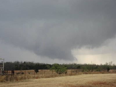
Thursday March 30 Photo
Below is a picture from early afternoon of wall cloud with tornado warned storm near Mullhall, OK (west of Stillwater) -- saw no tornadoes.

Welcome to the blog of Jared Guyer
From what I glanced at this evening, I still wonder about the impacts of early day convection from KS into MO on Thursday. However, models do suggest a narrow warm sector of recovery across eastern KS during the afternoon. Convective mode may leave a little to be desired, but certainly a tornadic window would exist mid/late afternoon given the low level flow fields in the recovering warm sector... rather enlarged low level hodographs thanks to 50 kt flow "off the deck". I wonder if much of eastern KS into MO is the high reward/high risk (in terms of tornadoes -- not necessarily a literal "high"!) of the day contingent upon the timing/degree of recovery. A solid coverage of large hail and eventual damaging winds seems likely otherwise. In some ways, I speculate a little "clearer" scenario (if my prognosis skills are capable of such!) may be severe/isolated tornadoes near the cold core from north/northeast KS into central/eastern NEB and perhaps western IA. Same thing may go for eastern OK, where morning convection won't be as problematic, with late afternoon/early evening development looking like a good possibility down to near the Red River, if not north TX. One thing is for sure, storms will be hauling with Bunkers motions of NE at 45-50 kts! Given my aforementioned logistics, I still plan to take a little detour into eastern KS. Morning trends will dictate the details I suppose, but my initial leaning is Topeka-Emporia. I'll hopefully have position/camera updates active (pending a laptop issue).
I'll be heading out of town on Thursday for Valpo's Great Lakes Conference. Although I can't chase in the classic sense, I'll have the opportunity to make a side trip if conditions warrant across eastern KS/far western MO. I have some concerns with impacts of early day convection and perhaps mode regarding high end/tornado potential (especially in the direction I'm heading), but widespread severe certainly looks probable across the eastern Plains/Missouri Valley into OK/north TX.
Most of you reading this probably know that Sunday was a rather violent severe weather day with an outbreak of tornadoes from eastern Kansas/western Missouri into the "homeland" of Illinois. Storm reports: http://www.spc.noaa.gov/climo/reports/060312_rpts.html
As of late Sunday night, the highest impact tornado damage appears to have occurred via a couple of very long lived supercells that tracked from west central Missouri into central Illinois. The tornado damage reports coming in from Springfield, IL tonight do not sound good at all -- numerous structural damage/injuries and missing people. Hopefully my extended family there is OK. I'll perhaps post some additional thoughts and/or data in the next day or two.
Will be chasing today. My initial target is Lawton in southwest OK.
It appears there will be adequate insolation/mixing near the dryline such that I believe there's a good chance at least isolated storms pre-dark today across west/southwest OK into north TX. I think development would remain sufficiently discreet given the forcing/orientation with kinematics otherwise favorable for supercells. RUC/NAM progs of 1500-2000 J/kg MLCAPE appear reasonable. Although initially marginal, low level shear should increase toward 00z largely owing to surface cyclogenesis and LLJ increase -- this scenario is supported by the latest RUC's suggestion of backing south/perhaps even southeast surface winds across southwest OK by early evening. Especially if low 60s F dewpoints are maintained, would stand to reason there is a fair tornado threat. Storms will be moving at a pretty good clip -- forecast Bunkers suggest 30 kts or greater. Looks like a significant severe threat will continue through the night into the ARKLATEX.
Marginal convective initiation scenario pre-dark and multiple laptop technical issues ("why is my laptop making that noise?") has me a no-go today. Will likely chase tomorrow... hopefully?!?
Namely since I'm off, I'm leaning toward a chase Tuesday. My current expectation is for isolated storms to develop from far north TX into west central/north central OK Tuesday mid to late afternoon. Some high clouds could be problematic, but I think there may be enough heating and the large scale appears adequately favorable for isolated development along/ahead of the dryline. Given storms, kinematics are supportive of supercells and perhaps a tornado or two given good low level shear and just enough boundary layer moisture (60F Td). Initial leaning for a target is the Hobart-Clinton-Anadarko corridor, but will later reevaluate whether north central OK is a better play. Wednesday looks even more favorable for supercells and perhaps a few tornadoes.
Several things to update on... I've actually managed to get some work done on the main part of my website -- http://www.deepconvection.com. One change for this season is I've added a page that will update my position when I'm out chasing, as well as show a webcam image from my car (pending an internet connection). The page is password protected right now, so send me an e-mail if you want access.
As I write this Sunday evening, it appears there could be chase prospects both Tuesday (7th) and Wednesday (8th) near here. More detailed thoughts later.

I am a meteorologist with the National Weather Service. My hobbies and interests include severe storms and storm chasing, baseball/playing softball, and politics.
